Project showcase
The Claypits, Glasgow’s Inner City Nature Reserve - Scottish Canals with LUC

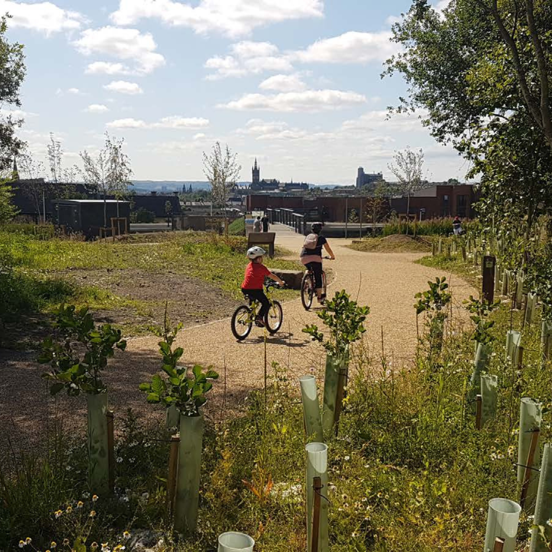
The Claypits is a large 17ha area of post-industrial site that straddles the canal. This project’s greatest achievement is its redesignation from ‘Vacant and Derelict Land’ to a ‘Local Nature Reserve’.
Where is the project located
North Glasgow
Who is the developer/client of the project?
Scottish Canals
Describe the context of this project and its neighbourhood and people?
The Glasgow branch of the Forth and Clyde Canal is located 1km north of the city centre. It meanders through various disadvantaged communities including Woodside, Firhill and Hamiltonhill. These communities lie within the 15% Scottish Index Multiple Deprivation most deprived areas in Scotland and suffer from some of the country’s worst health statistics. The quality of open space in these communities is poor. Many residents feel disconnected from other parts of the city and are rarely able to access and enjoy the benefits of natural or semi-natural environments.
The Claypits is a large 17ha area of post-industrial site that straddles the canal. It was designated as ‘Vacant and Derelict Land’, and formed a significant barrier to movement between adjacent communities and their respective facilities. Perimeter security fencing, steep topography and anti-social behavior discouraged access and use. Much of the site was also contaminated. It was perceived by many as unsafe. Nevertheless, members of the local community recognised the site’s untapped potential as a wildlife haven, its wild ‘green’ character, and its elevated views across city.
In 2014 a partnership between Scottish Canals and Glasgow City Council appointed LUC to lead a design Charrette, to work collaboratively with members of the local community and stakeholder groups to establish a shared vison, a cohesive development framework, and Green Infrastructure masterplan for the Claypits site. The main aim was to explore the site’s potential in terms of what a revitalised and multifunctional greenspace could offer in terms of contributing to wider sustainable development.
Tell us what you did and how it was designed and delivered. What do you see as the greatest success of this project?
The vision for Claypits was established during the Charrette based on a series of agreed strategic design principles:
- improve connectivity between communities and their respective facilities, whilst overcoming the barrier and constraints presented by the canal and associated post-industrial land;
- improve the health and wellbeing of local communities by encouraging safe active travel and activity;
- facilitate access to a distinctive, attractive and multi-functional new greenspace;
- enhance appreciation of industrial heritage and ecology;
- increase biodiversity;
- facilitate future sustainable development by integrating SUDS and service infrastructure.
LUC was retained to develop a masterplan and detailed proposals, and undertake further community and stakeholder engagement. This included Planning and Scheduled Monument statutory consent applications.
The design proposals sought to harness the unique ‘wild’ character of the site, and reinforce key views and the sequential spatial experience through a mosaic of habitats. The proposals included:
- 1.5km new pedestrian and cycle path infrastructure;
- Several bridges and boardwalk structures;
- Public realm enhancements at key gateway locations;
- Extensive tree planting;
- Significant SUDS infrastructure integrated with Glasgow’s Smart Canal scheme;
- Play and other features to encourage activity;
- Street Furniture, signage and wayfinding;
- Residential moorings on the canal.
The emerging design proposals, underpinned by the strength of community support and a robust design philosophy, helped Scottish Canals secure c. £7.5million from various 3rd party sources to deliver the project.
The project’s greatest achievement is its redesignation from ‘Vacant and Derelict Land’ to a ‘Local Nature Reserve’.
How does this public space bring people together, encourage inclusivity, and make a positive environmental impact to the wider place? How is the community engaged in the project?
One of the original main aims of the project was to ensure as many people as possible were brought together from the local community and interested stakeholder groups to work collaboratively to promote a sustainable and collaborative regeneration programme for the Claypits site. The primary aim was to promote the site for the long term benefit and wellbeing of local communities and to ensure access for all. This was achieved initially via the intensive Charrette and included a sequence of presentations, site walkovers and workshop sessions with over 300 people in a collaborative forum over a period of 4 days. It included several art outreach sessions out with the main Charrette venues.
One of the successful outcomes of the Charrette was the establishment of the volunteer Claypits Local Nature Reserve Management Group (CLNRMG) claypitslnr.co.uk/ Now a registered charity with over 3000 members the group now act as long term custodians for the site.
Following the Charrette LUC worked with Scottish Canals and the CLNRMG to organise further community exhibitions, guided tours and stakeholder workshops which informed the development of the detailed proposals.
The CLNRMG continue to maintain and promote the Claypits as a community asset. They activity organise various events and activities to attract people to the site, including:
- Monthly Volunteer Litter Picks and Graffiti Cleaning
- Wee Weans Wander
- Birdwatching tours
- School visits
- Guided Walk and Talks
- Community Tree Planting
Please share any data or figures that support your entry about how this public space or landscape intervention has made a positive social or environmental impact, for example biodiversity, increased dwell time, flood or drainage mitigation, wellness or safety or other ecosystem services.
Once designated as Vacant and Derelict Land the Clayptis is now Glasgow’s only inner-city Nature Reserve. It provides free access to a semi-natural environment for thousands of people in an area that was historically disadvantaged, deprived, and suffered from poor health statistics.
From pedestrian and cyclist counters installed at strategic gateway locations a total of 791,748 people were recorded using Claypits during 2021. This equates to approximately 60,000 users per month, 15,000 per week or 2,000 per day, with seasonal variation. The distribution of pedestrians to cyclists is approximately 75 / 25% respectively.
A recent study by Glasgow Caledonian University, commissioned by Scottish Canals, concluded that people living within 700m of the newly regenerated Glasgow Canal has a 15% lower risk of suffering from cardiovascular disease, a stroke or hypertension. It also lowered their risk of diabetes by 12% and obesity by 10%.
Animal and bird species that have been recorded on the site include: Roe Deer, Otter, Water Rail, Peregrine Falcons, Newts, and a wide range of other birds, insects and flora accommodated within an enhanced mosaic of difference habitats. Over 8,000 trees were planted as part of the scheme.
SUDS infrastructure, in the form of naturalistic swales and basins, was integrated into the project in partnership with Queens Cross Housing Association. This will facilitate the construction of 700 new homes in the adjacent Hamiltonhill community.
On 3rd August 2021 a Motion was brought to the Scottish Parliament congratulating all involved in the delivery of the Claypits project.
Festival of Pineapples
24-26 February 2026
Pineapples prize giving night
April
Pineapples at Festival of Place
10 June 2026
© The Pineapples - Tweak Ltd. 124 City Road, London, EC1V 2NX. Tel: 020 3326 7238


